Doxycyline and Altitude and Heavy Bear Canisters - Oh My!
June 9th - 11th - Three Zero days in Kennedy Meadows
I took three zeros in Kennedy Meadows, getting caught up on things and getting ready for the Sierras. In case I haven't explained it yet, a "zero" is hiker terminology for a day that you don't hike at all, and a "nero" is the same for a day when you hike only a few miles, usually because you arrived at a stop in the morning or left somewhere in the evening and hiked a few miles before camping. It's generally recommended that you take a rest before heading into the Sierras, but my three zeros were more the product of everything I wanted to get done there than anything else. I spent the first day uploading photos and writing my last blog post in a trailer owned by Tom, a trail angel I'd met at the kickoff party. In the evening Mrs. Sauffley stopped by and drove a group of us including her son Tom and his girlfriend Ariel to a restaurant called the Grumpy Bear to get burgers.
 |
| Tom and Mrs. Sauffley |
The next day Tom's internet was down and I had some more business to take of online, so I caught a ride into the nearest town with the father of another hiker who was leaving after visiting his son. This town was not terribly near, and was called Ridgecrest. A total of four hikers went, and and after buying a balaclava for the Sierras and eating a sinful amount of Chinese food (literally, it came with a side of hot wings) I found a laundromat called iWash that had computer access for $5 an hour. Kitten had come with me to the laundromat while the other two hikers stayed in a doughnut shop, and he suddenly whispered
"Look! It's the people from the Grumpy Bear! Go!"
We chased them out to the parking lot, and found out that their names were Sherrie and John, and that they would be happy to drive us back up the mountain after they finished their laundry and grocery shopping. We called the other two hikers and they didn't want to wait so they split a taxi out of town, to the base of the road that winds up the mountain to Kennedy Meadows and planned to hitchhike from there. I got to take care of all of my business online and when we finally left town, in the dark, we were the car that picked the two girls up at the base of the road up the mountain. Luckily John's truck was big, and the four of us sat in back seat of the extended cab comfortably.
"Are you two OK?" They laughed.
"Yeah, actually, it was kind of fun."
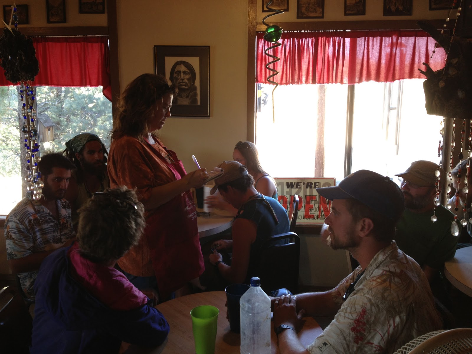
Sherrie told us to come in for dinner the next night, saying that she would have some steaks for us. We were grateful for the rescue from Ridgecrest and liked them both, so Kitten and I rounded up 20 or 30 people to hit the restaurant for dinner. I spent my third zero organizing my food and bear canister in my pack, and in the evening Sherrie came as promised to pick us up. It turned out that she hadn't expected more than a few of us and it was only she and her mom there, but working in restaurants is one thing that I actually know how to do, so I jumped in the kitchen and peeled potatoes, cut french fries, and sliced tomatoes and onions. Then I switched to the front of the house and ran food, took drink orders, and helped sort out who still needed what.
 |
| Sherrie taking orders at the Grumpy Bear |
 |
| The Grumpy Bear's Decor |
 |
| Dianne, Sherrie's Mom |
When we finally had everyone fed I wolfed down my steak, which was rare the way I love it and as big as my head. I was happy to help them out after being rescued from Ridgecrest but they insisted on buying my steak dinner and wine coolers, and Dianne, Sherrie's mom, even gave me my choice of the key chains that she had made and was selling in the restaurant. It now lives on my backpack, and hopefully will make it to Canada with me.
I also spent a lot of time at the Kennedy Meadows General Store, where I had dinners at the cafe, Ben & Jerry's and beverages at the store, received resupply packages, and camped in the wooded backyard. I liked the staff and the locals who hung out on the porch, but I was so busy there that I somehow failed to take a single picture of the place, which I regret.
June 12th
The next day I finally left, weighed down by eight days' worth of food and a heavy bear canister. The first section of the trail where bear canisters were required was about 40 miles in, so people typically picked them up there. Some are available for loan from Trail Angel Tom and at least one company offers a very good deal for PCT thru-hikers, but I neglected to arrange anything more than a week beforehand and was left ordering one at full price from REI, which didn't hurt nearly as much as carrying the damn thing.
 |
| One of the more interesting looking snakes I've seen |
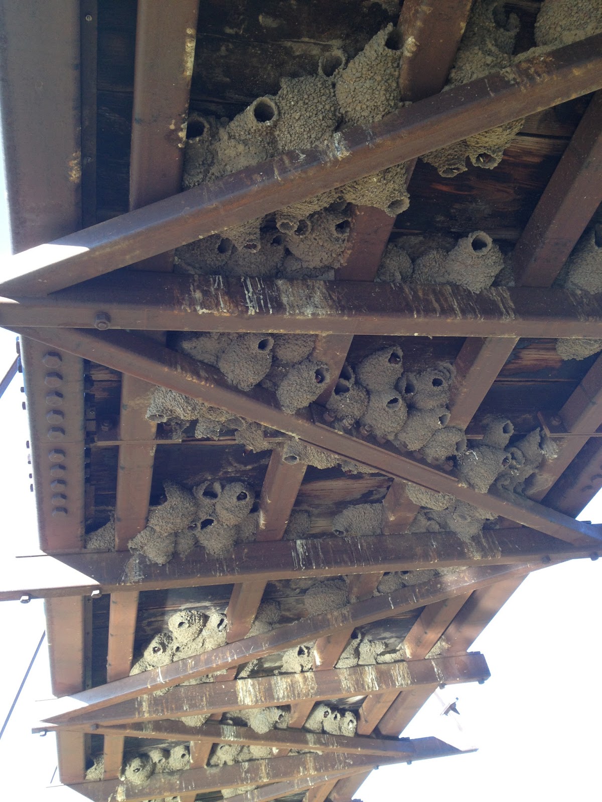
In the afternoon I reached the Kern River (come on, it's a creek) Bridge, which was heavily populated by swallows.
 |
| The Kern River Bridge (see the swallows flying around) |
 |
| Swallow's nests under the Kern River bridge |
A number of other hikers showed up and I sat eating and relaxing with
them for a while, but decided to try to get a few more miles in before
sleeping and took off again.
June 13th
I've been hearing an insect sound that I've been told is cicadas, which are on a 17-year cycle in this part of the world and are having their boom year this year. I took this clip of their sound, which I hope will be audible (I can't tell from this computer), and I'm hoping that someone can tell me if any of this is correct:
 |
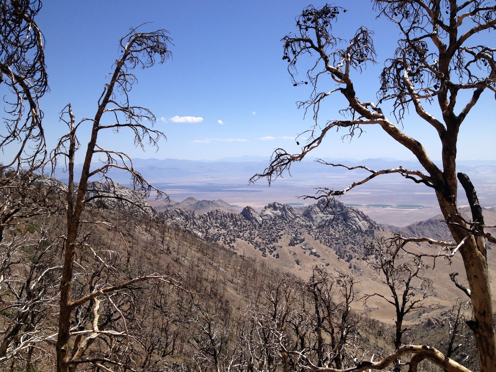
| It almost looks like some kind of salt flats down there, but I couldn't really tell. |
 |
| The dead are more intertwined with the living in nature. |
Some time during the day Kitten caught up with me, having slept back at the bridge but wanting to put some distance between himself and the large group that had gathered there after he'd been woken up at 5:00 AM by loud music. We had one crazy experience that day, which was fighter planes flying what seemed only a few hundred feet above us, although it was probably much more. I don't know what they were practicing, but the nose and the closeness of them as they buzzed the ridges was so intense that we were left speechless. I have no great love for the military-industrial complex, but there is something about seeing a fighter jet fly over a mountain ridge, right above your head, upside down, that is pretty freaking cool.
Kitten and I hiked together to Diaz Creek and were setting ourselves up for the night when King Street hiked up. He'd only left Kennedy Meadows the previous evening, but had hiked 31 miles to get ahead of the same crowd and to catch up with us, and we were thrilled to see him.
June 14th
The next morning we reached Poison Meadow Spring, which was the last entry on the water report. The water report had been absolutely critical in getting through the first 700 miles of the trail, and it was strange to hike on without that source of information on water sources. I would soon get used to crossing creeks every few miles and not worrying about water, but it seemed incredibly strange at first.
 |
| Poison Meadow Spring, mile 746.8 - the last thing on the water report |
 |
| What am I doing here? Trying to long-distance karate kick Kitten? |
 |
| Kitten looking out on Chicken Spring Lake |
 |
| King Street and Kitten being goofy |
 |
| I think I'm trying to dance in this picture... |
 |
| This sign cracks me up, since I can't imagine how you'd get livestock up here or what you would graze them on if you did. |
We hiked together to Rock Creek, the site of the first bear box on the trail. This was important because it was our first night inside the area where bear canisters are required, but we still had too much food to fit into our canisters, and we wanted to take the regulations seriously. Together with another hiker named Hitch we cooked 200 feet from our sleeping area, and then stowed our canisters and their overflow of food in the bear box before crawling into bed.
June 15th
 |
| The view from my tent in the morning at Rock Creek |
 |
| My first bear box, at Rock Creek |
The previous day I had seen Claire and Charlie, the British couple that Jessie and I had hiked with between Paradise Valley and Idyllwild. Charlie had gone back to Britain for three weeks to visit his mother and Claire had spent the time volunteering on an organic farm to learn the farming practices, and they had just gotten back on the trail together with their friend who had come from England to hike a stretch of the trail. I'd been thrilled to see them again, and that morning they hiked up on us and stopped to make breakfast, and we got to catch up. We would see them again at the Crabtree Meadows Ranger Station, and will hopefully see them again after that.
 |
| Charlie and Claire back on the trail along with their friend visiting from England for a stretch of the trail |
 |
| Two hikers fording the creek at Crabtree Meadows |
I reached the Crabtree Meadows Ranger station mid-day, and King Street told me that the plan for hiking Mount Whitney, the tallest mountain in the lower 48 states and a short side trip from the PCT, had changed. Kitten really wanted to see stars 360 degrees around him and we had agreed to hike up the mountain during the second half of the night and wait for the sunrise before heading down, but had been advised against it by several hikers, who said that it would be miserably cold and even dangerous. King Street said that the plan was now to take a few hours' rest, hike up that afternoon, and spend the night on the summit before hiking down the next morning. I was worried about the cold but wanted to do Whitney with the boys - partly because the Dirty Girl (who, by the way, saved my butt by sending me a fuel canister at Kennedy Meadows, not to mention a few other thoughtful goodies) had made me promise her not to hike Whitney alone, but also because I wanted to share the experience with people that I like. So I agreed, and we also recruited Puppy, another girl who we'd been bumping into a lot on the trail and all liked.
We hiked three miles to Guitar Lake, where many hikers camp before summitting.
 |
| Guitar Lake |
The area was absolutely full of marmots, which are the single cutest and most entertaining animal to ever walk the earth. This marmot below bounded by me, threw itself onto a rock, and then played dead until I left:
 |
| A marmot playing dead |
About two miles from the summit the trails from the east and west meet. PCT hikers come from the west, while people who are just summitting Mount Whitney come primarily from the east. I think the trail from the west is actually much easier, probably because the PCT is already at about 10,000 feet at that point, leaving less than 5,000 to the summit.
 |
| Less than two miles from the summit! |
 |
| I guess that's why they call it Guitar Lake. |
There was only one patch of snow on the way up, and that was only maybe 100 feet long. In a hurry to reach the summit by sunset, I didn't even stop to put my Yak Trax on for traction.
 |
| King Street going through the only snow on the ascent |
This was fine, because there such a narrow path worn by hikers, that there wasn't really anywhere to fall.
I reached the top with about 15 minutes to spare.
 |
| On top of Mount Whitney! |
Puppy had stayed a short distance down where Verizon phones got service, but the boys and I changed out of our sweaty clothes and into long underwear, and took photos of each other as the sun set.
 |
| Sunset at the top of Mount Whitney |
 |
| You really can't tell, but this is me chugging a shot of Fireball after the sun set. |
Puppy came up a few minutes later, and the four of us made our beds in the small hut at the summit. We had heard from another hiker that the hut was big enough to sleep two people and full of trash, but found that it could comfortably sleep four and could even fit six, and the few random pieces of trash didn't bother us. It was also warm inside, having been constructed with stone walls and a tin roof, which apparently allowed it to absorb the heat of the day and store it through the night. A plaque inside warned against taking out the floorboards, saying that the wood was protection against lightning, but ripping out the floorboards hadn't been on our to-do list anyways, so the hut was safe.
June 16th
Kitten, who had been intent on having 360 degree stars, had never actually laid down in the hut and had spent the evening outside while the rest of us slept. He woke us up for sunrise, and we staggered out with our sleeping bags at sat with him on the rocks. I'm grateful for the ease of digital photography, because I don't want the sunrise on top of Mount Whitney, surrounded by good people, to fade from my mind soon.
 |
| Staying warm watching the sunrise |
 |
| Sunrise on top of Mount Whitney |
 |
| Kitten, me, and King Street (left to right) |
 |
| Puppy! |
 |
| Our shadows on the hut we slept in - a plaque said "Erected 1909 - Smithsonian Institution - Hodgkins Fund" |
 |
| Signing the register |
I started down before the others. I'd hiked early sections of the trail with King Street and Kitten and hadn't had much trouble keeping up with them, but everything had been harder for me in the Sierras. I didn't know if it was because of the added weight of the bear canister (the boys carried them too but I'd started the trail with a lighter pack and was less used to carrying a heavy one), or side effects of the doxycycline, or if I just had a harder time with altitude than the others, but I couldn't keep up with the other three now. On the way up the boys had reached the summit 20 minutes before me, despite having taken a half-hour break at Guitar Lake while I kept hiking. I'd also had some other strange things going on - one was a burning feeling on my skin, regardless of how many times a day I applied sunblock. Charlie explained to me that sun sensitivity was a side effect of doxycycline, and that it typically wasn't prescribed for anyone who was going to be spending a lot of time outside. The other thing, which I still don't understand, is pain in my thumbs (a little in the other fingers but much stronger in the thumbs), like the pressure inside them is too great, which is exceptionally painful when they're exposed to cold, like when I'm filling a water bottle from a creek. As of the time I'm writing I have a day and half of the doxy left, so I'll just have to see what goes away after that.
 |
| Heading back down |
On the way down I tried out my Yak Trax on the patch of snow. They're a nice alternative to microspikes if you're really not going to encounter much snow - they don't have actual spikes but still provide some traction and weigh only a few ounces, making it a minimal commitment to carry them. The only problem with them is that they don't secure over your foot, and thus can fly off and be lost very easily.
 |
| Trying out my Yak Trax on the snow patch |
 |
| With all of these majestic views it's important to remember the little things. |
 |
| On the way down we saw G-Dub, who had healed and was on his way up to the summit. |
 |
| The gang heading down |
Back down at the ranger station we cooked lunches and rested, and decided to leave at 4:00 PM. I was amazed to find that I really wanted to get some more miles in, despite all the fatigue. This was partly because I wanted to do the steep climb up to Forester Pass in the morning rather than in the afternoon the next day, but also because I really just felt like I wanted to move a little more.
 |
| The least private toilet I have ever used - the campground is all around it, but there are walls on only two sides. |
Since the previous day we'd been seeing a helicopter make air drops, and my curiosity got the best of me. I walked through the trees to where it seemed to be dropping things, and found a small construction crew. They were friendly, and explained that they were building a new ranger station. I asked if they had been helicoptered in as well, and was impressed to hear that no, they had hiked.
 |
| A helicopter making a drop |
 |
| The construction crew stacking the contents of the drop - bags of cement |
 |
| The construction site of the new ranger station |
Hiking out I was enamored with the beauty of the Sierras, finding that I spent nearly as much time taking pictures as walking.
 |
| This tree had it's roots in the wrong place. |
 |
| Close encounters of the marmot kind |
I camped at Tyndall Creek. Puppy and King Street had stopped a few miles earlier but Kitten was also there, since he still had too much food to fit in his bear canister and the camp site had a bear box. I realized that my bear canister hadn't spend a night outside of a bear box since I'd entered the zone where it was required (the night I'd spent on Whitney it had stayed in the Crabtree Meadows bear box - I'd obviously had food on the mountain but there are no bears at that altitude). If I were giving advice to another hiker, I would probably tell them to ship their bear canister to Independence (the town at the end of this stretch of trail) and just use the bear boxes for this stretch. That way, they could worry about acclimating to the altitude and the intense climbs and the week's worth of food before throwing a bear canister in on top of it all.
June 17th
In the morning I forced myself to get up earlier than I wanted to, and trudged the first three miles towards Forester Pass. These three miles were a shallower climb, and the fourth would be steep.
 |
| Heading for Forester pass, visible on the horizon on the right side |
Before the fourth mile there was a stream, and Kitten caught up with me there. We ate and rested a little, and then charged up. It took me a half-hour, and Kitten less. At the top we took each other's pictures, and I found that my iPhone, which I'd been using for my camera, was out of memory. I'd recently subscribed to the service Dropbox, which lets you upload all of your photos to a website (I have my phone set to do it automatically whenever it picks up WiFi), and judged that money very well spent. I'd done it in case I lost the phone, but I hadn't even though of having to delete photos.
 |
| Kitten on Forester Pass, trying to interest a marmot in a Cheerio |
 |
| Me on top of Forester Pass |
On the way down I put on my Yak Trax for a snowy patch and decided to keep wearing them through the dirt rather than stopping to put them on and off each time, but after a few minutes I looked down to find that one was gone. Since they're rubber and stretch on I had no idea how far off the trail it had flown off, and decided it wasn't worth hiking back up the mountain to look for it. I stashed the other one in my bag and kept going, grumbling. At one point my foot slid in the fine gravel and I fell hard, somehow miraculously not hurting myself, but doubling my disgust the Yak Trax, regardless of whether they were even designed to provide traction in gravel.
 |
| Coming down from Forester Pass |
Kitten hiked a lot faster than me, and I'd lost him within a few minutes
of leaving the pass. I've fallen into the habit of trying to keep up
with friends while hiking, but as soon as I lose them I immediately
start noticing the scenery and taking more pictures.
 |
| Look at that diagonal section of rock - I've got to find time to take a geology class... |
I stopped for lunch near some pretty green plants, and another hiker arrived shortly and stopped as well. She went by Lionheart, and she was carrying my lost Yak Trak. I thanked her, we chatted about the trail, and she told me the name of the pretty green plants, the second word of which was "lily," but the first of which I've forgotten.
 |
| The pretty green plants |
 |
| The PCT runs on the John Muir trail now, and will through most of the Sierras. I still haven't read anything written by John Muir, and resolve to do so. |
I left the PCT at the Bullfrog Lake junction. This trail runs about three miles before joining the Kearsarge Pass trail, and then runs maybe another five miles over Kearsarge pass and down to the Onion Valley trailhead.
 |
| Bullfrog Lake |
 |
| Heading towards Kearsarge Pass |
 |
| On top of Kearsarge Pass |
 |
| Heading down from Kearsarge Pass |
The trailhead is fairly remote, and runs out to a tiny town called Independence. From there most hikers go north to Bishop, but I had fuel canisters waiting for me at Lone Pines, which is to the south. It was already after six, and it didn't look good. A single pair of day hikers stood in the parking lot, and another PCT hiker was talking to them. I asked if they were headed out towards Independence.
"Yes, we are." I gestured to the other hiker.
"He's with his wife and they have two dogs. If you can fit them, you should - they've been here longer." But the couple said they didn't have room for the dogs, so I walked with them towards their car.
"Can I ask where you're headed?" I asked the husband.
"Oh, we're headed to Lone Pines."
"Seriously?" I had spent less than a minute arranging one of the toughest hitches on the trail so far.
I usually take pictures of people who help me so I can thank them in my blog, but sometimes I'm too distracted to remember to do it, and in my low blood sugar daze I completely forgot to take a picture of Larry and Susan. I can tell you that Larry is an engineer and Susan is a stay-at-home mom and that their kids are 14 and 16, and that they live in a nice neighborhood outside of LA. I can also tell you that they have a permit to climb Mount Whitney later in the season, and that I pitched the "hike up in the evening, hike down in the morning" plan to them and hope that they'll do it and have as much fun as I did.
Larry and Susan drove me right to the hostel and even came in with me to check out the little store inside. I registered for my room and the girl behind the desk was about to show me to my room, when I asked where the computer was.
"Computer?"
"Yeah, the guidebook says you have a computer." She shook her head, and I showed her the entry in the guidebook, as if that would make a computer appear.
"We just have the one behind the desk - try talking to John." A man sat at a chair in one corner of the lobby, next to an assortment of computer equipment. I approached him, and found that he was with an organization called
Eastern Sierra Connect Regional Broadband Consortium (ESCRBC), whose mission was "facilitating broadband capacity and adoption in eastern Sierra." John was setting up a workstation for low-income seniors but the program hadn't started yet, and he didn't mind if I used the working computer. I showered in my room and ate at the restaurant across the street, and then came back, delirious.
"You need to go to bed," John said. "Can't you do this tomorrow?"
"I can use the computer tomorrow?"
"Sure, I won't be here, but we can let the front desk know that you have permission to use it." So John and I sat chatting for a half-hour before he set off for his 40-mile drive home, and I crawled in to bed and then spent today blogging thanks to John and ESCRBC.
 |
| John! |