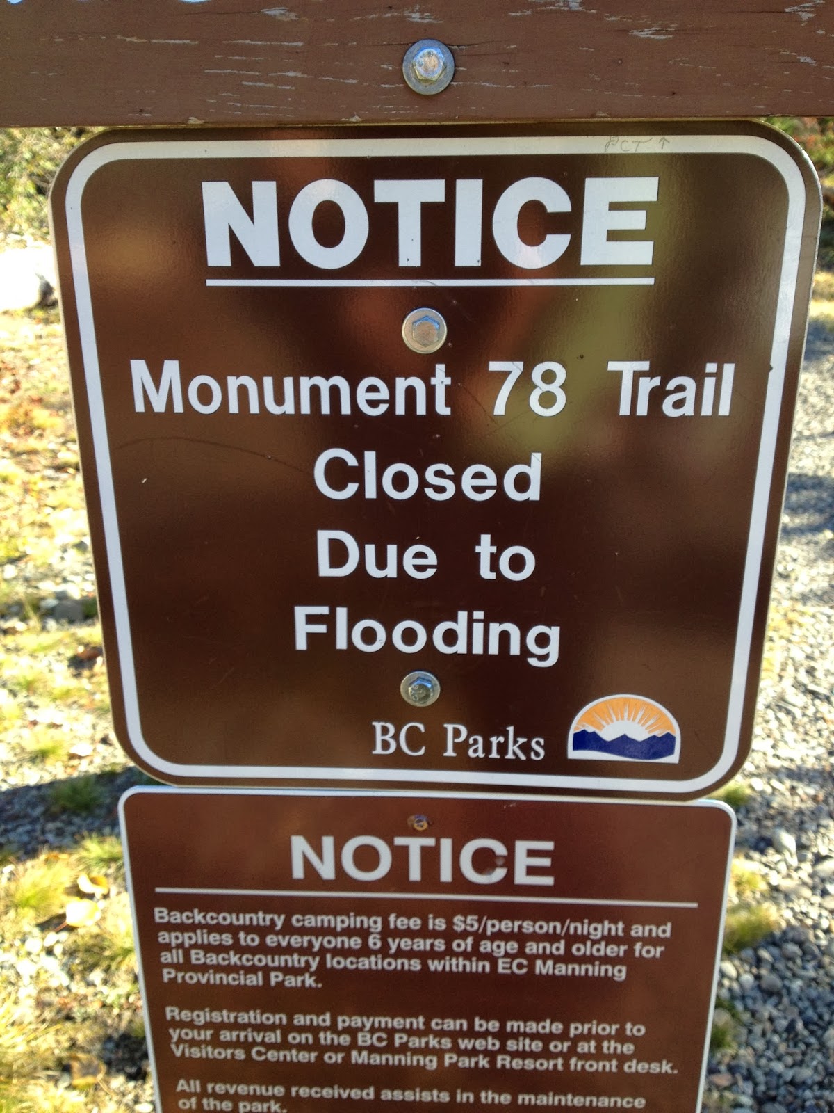
We arrived in Manning Park to a sign that the trail we'd just hiked was closed due to flooding. It looks like a fairly permanent sign so maybe the washouts had happened longer ago than I had been speculating, I don't know.
 |
| This is where people levitating above their bicycles can cross the road. |
 |
| OK, I saw a lot of funny signs over the past six months, but this one is the new champion. |
We spent a subdued night at the hotel in Manning Park, and then left in the morning to hitch back down to Stevens Pass. Standing in front of the hotel grounds we were lucky enough to get picked up by Lisa, who was driving hours to the east. She would take us as far as Oosoyoos, the Canadian town a few miles north of the border crossing, and from there she would continue east and we would turn south towards the American border. We had a few hours in her car and we talked about our lives, and what to do for a career, and where to live. Lisa had just been trained in a particular methodology for helping people figure out what direction to go in life and it sounded exactly like what I need right now, but of course I didn't write its name down before it slipped out of my head.
When we got to Oosoyoos, Lisa turned south.
"I might as well just drive you there, it's only a few miles and I've never seen that border crossing." We were grateful for not having to hitch another ride to cover the last few miles to the border and we thanked her, and then we all learned an important lesson: American border crossings are not like airports, they are not designed for curbside drop-offs.
We were at the border in minutes but suddenly realized that we were in line to cross into the United States, and Lisa was without a passport or an enhanced driver's license. A guard stood near my window so I rolled it down and we explained that we didn't want to drive the car across the border, Lisa only wanted to drop Chris and I off, and asked how could we turn around or just back out of the line we were in. He barked at us that we could do no such thing, and placing his hand on his gun, ordered us to roll down the back window. The back window revealed Chris, sitting calmly in his seat, but the hand remained on the gun.
We thanked the creep for his help and inched forward in the line. Lisa was looking a pretty nervous, and my heart went out to her. Trying to do something nice for us had resulted in her stuck in a line waiting to cross an international border without the legally required identification and with two strangers and their big backpacks in her car. They would more than likely search the car, and she had known us for two hours. I looked at her and said
"There's at least one thing I can promise you - there won't be any surprises in our bags, we don't even smoke pot. We drink a little whiskey but we're not even carrying any of that, and we both have our passports and the little permits that we're supposed to have to enter Canada on the PCT. So it looks like we're already in a little trouble, but I promise that we don't have anything in your car that's going to make it worse."
Lisa nodded, and we continued on. The next hour was spent with our paperwork being checked, the car being searched, Lisa being interrogated on some time that she'd briefly lived in the U.S. 30 years prior. The American border guards at least let us use their nice clean bathroom, though, and no one had their hand on their gun while they talked to us. They also treated us as a group and kept us together with Lisa, which meant that we could stay with her until she was cleared and allowed to turn her car around and head back to Canada. Undaunted after all of the drama, upon being cleared she refused to go until she could give us apples and protein snacks from her car, and we hugged her and took pictures with her before we let her drive away.
 |
| Lisa and I in front of the Canadian-American friendship monument |
We got a smattering of short rides south from the border, one of which left us at the same grocery store in Tonasket where I'd bought food for the last leg of the trail before Laurie picked me up. We bought enough food there for eight days - it was 105 miles from Stevens Pass to Stehekin, where I'd mailed a resupply box back before the snow hit, we figured we could do it in 7 days x 15 miles a day but carried an 8th day of food just in case. The Stevens to Rainy section of the trail had apparently been harder hit by the snow than that north of Rainy but it had also had more time to melt, so we decided that 15 miles a day was a reasonable assumption.
We got another town or two south before the rides seemed to dry up, except for a few cars that were headed to the
Okanogan Barter Faire and stopped to ask us if we wanted a ride there. The fair was east on Highway 20 so the offers did us no good, but the prospect was awfully tempting - the fair is a huge event and draws thousands of people, I think closer to 10,000 than 5,000, and although it's a big hippy party scene, it's also an actual barter fair. I remembered a woman in one of the small towns we'd walked through on the road walk telling me the two vegetables she had shortages of for the winter and the two she had surpluses of and would offer in trade, and I'd been planning to go to it after finishing the road walk, although that all seemed like lifetimes ago now that I'd been in the mountains, walking through the snow.
I'd posted a message on the PCT 2013 Facebook page to see if anyone else wanted to hike out of Stevens but needed a group to go with, and I'd been in touch with a hiker named Elizabeth who was considering hiking this leg of the trail with us. Elizabeth's dad kindly volunteered to come and pick us up all the way up in the town we'd hitched to just a little south of Tonasket, but as soon as he agreed we got a lift with Dan and Karen so we called him back and asked him just to pick us up on the south side of Lake Chelan instead. Dan was a welder, he and Karen loved motorcycles, and they were on their way back from a day trip to the Barter Fair. They told us about that and we told them about the PCT, and before we knew it we were pulling into the gas station just south of Chelan where we had asked Elizabeth's dad to meet us.
 |
| Dan and Karen and their little dog, whose name I can't remember |
I didn't manage to get a picture of Steve, Elizabeth's dad, but while we were in his car he got word from Elizabeth that she had hiked back to the trail on the side trail she'd previously gotten off the trail on (maybe 30 miles past Stevens Pass) and would see us between there and Rainy if we caught up with her. This meant there was no reason for him not to drive home to Bellingham that night so he just swung by his hotel room and gathered his things, and then dropped Chris and I off at the Dinsmores on his way over Stevens Pass. Chris said that when he'd met Elizabeth on the trail earlier in the season she'd been carrying a cardboard cutout of a dog, and the actual living version of the dog was in the car with us. The dog's name was Finn, and Finn had the impressive ability to sit completely still on Steve's lap so as not to interfere with his driving.
At one point Steve had to stop and we were stuck waiting in a line of cars for maybe 45 minutes, which was a strange thing to happen at night on Highway 2 and turned out to be because of
a head-on collision that took at least one life. Chris and I never saw the accident itself, it had happened west of Baring and when we got that far Steve left us with the Dinsmores. Jerry and Andrea had believed their season hosting hikers to be over and had cleaned the bunkhouse and removed all of the food that might attract rodents from the hiker boxes but when we arrived at their door at night, without having called, Andrea hugged me and sent Jerry out to make a fire in the wood stove. The next morning they made sure we had enough supplies, made sure we had breakfast at the general store, and made sure we had a ride back out to the trail before letting us go, and I promised myself that I'd do something good for them someday.
The Dinsmores' friend James Smith drove us out the the trail. He and Chris chatted in the front seat as I frantically tried to take care of some last-minute business online, and then he dropped us at the trail around noon.
 |
| James! |
We set off in the sun and chatted with day hikers along the way. Landscapes like the one below led to a lot of joking about the gear we were carrying (we still had the snowshoes and I'd added microspikes for this leg)
"Where are you, I can't see you through all this snow!"
"I can't see anything at all, I think I'm going snow blind!"
 |
| This first stretch resulted in a lot of jokes about the snow. |
 |
| Bear! |
We did finally reach snow in the early evening, and actually finished the day walking through snow in the dark. I was generally against night hiking in the snow but the top of Grizzly Peak was exactly 15 miles from Stevens Pass (we hadn't started until midday but had hiked most of the day on clear trails) and the snow really didn't cover the trail until we were almost at the top. The established campground was apparently buried but we found a sheltered spot underneath some trees a few hundred yards further and Chris had the tent up in no time, and in the morning we snowshoed the short distance back to the peak and took a few pictures.
 |
| On top of Grizzly Peak |
 |
| Chris's shadow and I on top of Grizzly Peak |
 |
| We saw evidence of a lot of small avalanches like this one, but not of any larger ones. |
 |
| Bear again? |
 |
| The 2,500 mile mark didn't mean a lot to me since I was doing this section out of order, but I did love that it was built out of the pine cone pieces discarded by squirrels. |
We made 15 miles again the second day, and camped on Lake Sally Ann. The elevation profile combined with our mileage meant that we were spending goods chunks of our day at lower elevations, but hiking back up to camp at about 5,500 feet. The snowline varied drastically in elevation depending on the amount of sun the hillsides received, but this basically meant that although we weren't spending all day hiking through the snow we were consistently camping in it.
 |
| Night #2's campsite, on Lake Sally Ann |
 |
| Chris |
 |
| The amount of snow on the ground in a given area seemed to have much less to do with altitude than with how much sun hit it during the day... |
 |
| ...I think this valley illustrates it pretty well with one hillside and even the bottom completely snowy and the other hillside completely snow-free. |
 |
| Most of the lakes we saw weren't frozen over, but this little one was. |
On the third day we ran into Elizabeth. We had lunch with her and she hiked on a little ways with us, but she'd already decided to call it a season and headed back to hike out the side trail after a few hours. We were sad to see her go but both admired the way that she was able to make what she felt was the best decision for herself without any drama. She gave us some foil packets of albacore and sockeye, much nicer fish than what was in the packets that could be found in standard grocery stores, and an immense quantity of snacks, we exchanged hugs, and then she was gone.
 |
| Elizabeth! |
 |
| Although the avalanches were small and not numerous they were sometimes
hard to walk through - the snow was pretty hard but there were plenty of
holes and it always looked like it would collapse underneath me. |
That day was by far the hardest north of Stevens Pass with almost consistent snow, and we were not making good time. Almost exactly at mile 2515 (by Guthook's mileage) there was a saddle, followed by a long, steep descent from almost 6,500 feet down to 3,800. I looked down from the saddle at the snowy path, knowing that this time of day the snow would be soft enough that I'd need to wear snowshoes, that it would be some distance before the terrain flattened out enough to hope for a campsite, and that it would be dark before too long. I was tired too, and really did not feel like picking my way down that hillside. I asked Chris and he agreed to camp right there on the saddle, making our third day's mileage only 10 and carrying on with our habit of camping at the highest point we'd hiked to all day. The views were pretty amazing, though, and the last thing I remember as I was falling asleep was the soft whirring and clicking of Chris's camera on its tripod outside the tent, snapping shots in a series with which he would create a time-lapse animation of the stars moving across the sky. I didn't take proper advantage of the situation photographically, but I'll include at least a shot or two that he took from here in my supplementary post with his pictures for this section.
 |
| On the third night we camped right here on this saddle (Portal Peak is
to the left) and Chris took some good shots from it, I'll include one or
two with his photos of me from this section. |
It was the first, and maybe the only night that we slept right on top of the snow. On most nights we slept surrounded by it, but Chris would pitch the tent under a tree or somewhere else that the ground was clear. On the saddle there was nowhere else to sleep, though, and for roughly the millionth time I was thankful that I'd bought the big thick NeoAir mattress and the 15 degree sleeping bag. We went out together and foraged for firewood, finding so much that Chris used some of the longest pieces to construct a tripod from which to hang clothes for drying. My "waterproof" socks were soaked after the full day in the snow but they worked well enough that it was worth drying them and starting over again in the morning, so I got in the habit of drying them as much as possible at night and then sleeping with them at the bottom of my bag so they'd get warm, and this made all the difference in the world when getting dressed in the morning.
 |
| Chris rigged this up for drying clothes over the fire. |
The next morning we headed down the steep slope. While in Baring I'd picked up a pair of microspikes from my belongings at the Dinsmores. A couple who had called off their thru-hike somewhere north of Stevens drove over the pass on their way home, and in an impressive display of altruism they stopped at the Dinsmores on their way and gave away all of their snow gear that they thought might help other hikers. I hadn't really spoken with them and didn't even realize what they'd done until after they'd left, but New Orleans had gotten the woman's microspikes and had passed them on to me before we'd left for the road walk. I was really grateful for them now - it was incredibly hard to navigate steep slopes in snowshoes, but it was slick enough that I really needed traction. I really think that they would be a useful addition to any long trip through snow because they allow the wearer to navigate slippery surfaces that are too steep or too narrow to walk in snowshoes comfortably.
 |
| I'm so glad I got to come down this first thing in the morning. |
 |
| Is that a bridge up there? Let's zoom in... |
 |
| Oh yeah, there WAS a bridge! |
Throughout the summer I'd had the same conversation repeatedly:
"Where are you from?" In truth, I don't live anywhere. I have half of my belongings in a high school buddy's house outside of Bellingham, Washington and half of them in my sister's garage in southern California. The last place I paid rent was in Portland, Oregon, but that was only for six months and before that I spent almost four years in the Republic of Georgia. So, I would usually ask
"Do you mean, where did I grow up?" and people would usually say yes to that, so I would tell them that I went to Mount Baker High School. If people are familiar with the North Cascades, as many people along the length of the PCT are, then that's enough.
"Oh," they would invariably say, smiling, "you're walking home!" and I would explain how this was incorrect. I would tell them how I hadn't lived there for almost 20 years, how even my mother had moved away from the area after my father died, and how I had no plans to live there again. Yet, as we neared Rainy Pass, where Highway 20 runs out to Skagit County, the next county south of the one I grew up in and the county in which my brother lives now, the woods started to feel in a strange way like home. Chris said that what I was responding to was the small amount of Washington rain forest that PCT runs through. I grew up in the Nooksack Valley which isn't rain forest so maybe it wasn't a feeling of familiarity but rather just a feeling of connection, I don't know, but the moment I started to feel it for the first time I stopped and took the picture immediately below:
 |
| A little glimpse of the Washington rain forest... |
 |
| ...and a little more. |
There were washouts, like the creek below, which made me think more of home. My earliest memory is of my father holding me and my mother holding my baby sister on the landing half way down the stairs of my parents' first house. My brother Sather was there too but he's not in the memory, and other seemingly random things are there - I was wrapped in the rainbow afghan and my sister was wrapped in a purple and yellow blanket with human figures scattered across it, the "peoples blanket" as we always called it. I remember them carrying us down to the first floor, where huge trees were stuck through the front wall of our house. The debris blocked the front door and I remember my father carrying me, wading through the mud and sticks on the living room floor, until he reached the window on the south side of the room. Then I remember his big hands under my arms as he lifted me through the window and handed me to the flashlights who were outside. The flashlights were neighbor men who had come to help us, and the debris was a huge landslide that had hit our house directly. We were on the front page of every newspaper in the country, and they say that all memories before about the age of four are manufactured, but why would I remember exactly which blankets we were wrapped in and not remember that my brother was there? If I had subconsciously made up the memory, wouldn't he have been standing next to us on the stairs?
When my sister got married I used my maid-of-honor speech to tell her my first memory of her and to give her the blanket she'd been wrapped in; I still had both of them almost 30 years later. There was more to the speech, about how I had watched her grow and become this amazing woman that she is now, but no one could understand it because I was sobbing so hard. The guests were looking at each other and trying to figure out what I was talking about, but basically all they got in the end was that I gave her an old blanket and blubbered intensely.
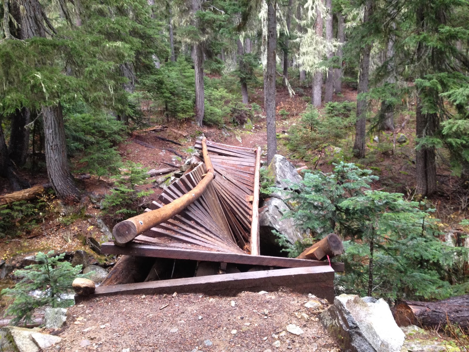
 |
| It's not hard to see how so many bridges were washed out, it looks like the area gets its share of flooding. |
 |
| This one was broken but it was still fairly civilized,... |
 |
| ...but I swear if I ever win the lottery I'm going to buy northern Washington PCT a bunch of new bridges. |
That fourth day we hiked 15 miles to the next high point, which was just above 6,000 feet. From it we could see across the next valley, and could see the trail switchbacking back up through a burned section on the other side (see picture below). It looked impossibly far away and I couldn't even see the floor of the valley in between it and us, but here's a perfect example of the craziness of hiking the PCT: By late morning the next day - literally just a few hours of hiking later - I would be standing on one of those switchbacks, looking back in this direction, not sure which of the snowy mountain passes we'd even descended from.
 |
| See the trail switchbacking through the clearcut on the other side of the valley? |
We hiked down another mile and a half to Mica Lake where Chris had camped on his way through this section the first time, and set up camp there.
 |
| Chris makes a fire by Mica Lake on our fourth night |
 |
| Mica Lake |
On our fifth day we took a couple of alternate routes to shave a few miles off. The alternate routes seemed to mean less walking but scarier creek crossings, either because the official trail had previously run that way but the bridge had washed out as in the picture directly below, or because one had never existed there.
The creek in the picture below wasn't too bad - there was no decent crossing but it was shallow enough to ford so I just took off my shoes and socks and waded. By the time I'd gotten to the large rock in the middle of the picture Chris was on the other side and had thrown a piece of the washed out bridge across to it so I didn't even have to ford the deepest part, and it was generally uneventful.
 |
| Chris somehow got across without taking his shoes off. |
The second crossing that saved us PCT miles, however, was a lot less fun. The creek was too deep and running too fast to ford, and the only way to cross it that we could see was on the logs below. Where the log on the left with the big whitish patch angles up it's too steep to walk on, so at that point you have to move over to the skinny black log curling over on the right and walk on that, holding the steep long for balance. Add a thru-hiker's pack with a big pair of snowshoes sticking out of it on either side to catch on things and roaring, near-freezing water below, and you get scared. Or at least I get scared, that's for sure.
 |
| The scariest creek crossing for me |
Our plan for that day was to cross the Suiattle River and rejoin the PCT on the other side, and then to camp along it. When we got to river, however, I just didn't want to leave. I was sure this creek crossing would be traumatic and wanted to get it out of the way, but the side we were on had open sandy spaces and more firewood than even Chris would know what to do with. Chris is nothing if not a pyromaniac so it wasn't hard to convince him to camp there, and he soon had a huge fire roaring beneath a huge wooden tripod, upon which hung all of our wet clothes. It was a nice place to camp but there was another reason I'd wanted to stay there - this river reminded me of where I'm from. I grew up on the south fork of the Nooksack River in Whatcom County so this landscape resembled those from my childhood even more than the rain forest had and I got the feeling again, like I'd walked home.
 |
| Camping on the Suiattle River on the fifth night, with clothes drying above the fire in the background |
In the morning we still had to cross the Suiattle River. We packed up camp and scrambled a few hundred yards upstream through log debris, to the place where Chris remembered a sturdy log laying across the river. I looked at it, and looked at the river churning underneath it. The water was deep enough and running fast enough that I knew if I fell, that would be it.
"You wouldn't be able to get your pack off in time," I said to Chris, "you'd just get pulled under." He agreed and went to take care of some business. He told me to wait for him, but I couldn't. I knew the longer I stared at the water the harder it would be, and I would have more anxiety with someone watching me cross it than without. Moreover, while I generally assumed that Chris would rescue me from almost any situation I might get myself into, I didn't see how anyone could be helped if they fell into the Suiattle here strapped into a thru-hiker's pack. I straddled the log, and used my arms to pull myself forward a few inches at a time. The surface of the log was rough enough that I couldn't slide and had to sort of hop my butt forward repeatedly and my pack was heavy and wide enough with the snow gear that it was still scary balance-wise, but I just kept scooting and was up on the bank of the river on the other side when Chris returned.
 |
| The Suiattle River crossing |
He looked around until he saw me there, we exchanged a wave, and then he just walked across the log like it was nothing at all.
 |
| Chris just walks across the Suiattle River |
 |
| Read this sign - seriously, who wrote this? |
I got the "walking home" feeling in some places that weren't terribly spectacular, like the place in the picture below. I'd stop to snap a shot and I could see Chris wondering why exactly I'd want a picture of place, but there was no way to explain it.
Late on the sixth night we arrived at the High Bridge Ranger Station, and found it deserted. There was, however, a shelter with three walls and a long bunk along one of them, so we just laid out our sleeping pads and bags head to head and instead of making a big bowl of food to eat together just made a couple of Mountain House meals and laid in our bags with our heads together to eat them.
I needed to get a personal e-mail out and wanted to let Andrea and others know we'd gotten safely to High Bridge but there was no bus running into town so late in the season, so in the morning we started walking towards Stehekin.
 |
| On the road into Stehekin - I assume the channel actually shifted after
the tree was grown, but it looks like the tree just grew up right in the
middle of the water. |
After a few miles we came to the
Stehekin Valley Ranch, where the owner Cliff invited us in to use their WiFi to take care of my business. Cliff's wife Carrie made us tea and we chatted with them while I got my messages out, and then we thanked them and set off again.
 |
| The Stehekin Valley Ranch, where Cliff and Carrie took us in and helped us |
The snowstorms had come so early that much of the trail seemed to have transitioned directly from summer into winter, skipping the fall completely. Foliage rotted on branches, a dull brownish green, and we were so used to it that the road to Stehekin with its brilliant yellows took us by surprise.
 |
| Fall colors on the road to Stehekin |
Cliff and Carrie picked us up on their way to run and errand and drove us a few miles closer, and then we had walked a little further when we saw a truck approaching. I whipped around so quickly to try to get a hitch that I fell backwards, landing on my butt and my pack. The driver stopped and yelled, laughing.
"There's no way I'm giving you a ride, you're clearly unstable!" I was still laughing when we finished stowing our packs in the back of Bob's truck and got ourselves loaded into the cab. When we told him that we were hoping to pick up my mail drop at the post office he said that it was closed but drove us straight to the home of the assistant postmaster, who he thought would be willing to get our package for us anyways. She and her husband were out of town and everyone agreed that there was no way the postmaster would come in on a day off. I was disappointed not to have the bottle of Fireball that I'd sent in the box to celebrate the end of the trail. I'd originally planned to carry the pint all the way from there to the Canadian border, but carrying it just the 20 miles to Rainy Pass and drinking it there sounded even better. But, we had made it to High Bridge in 6 days instead of 8 and had plenty of food and fuel, and there was nothing to stop us from hiking the last 20 miles without the box.
Bob took us to his house, made us sandwiches, showed us the shower, the laundry, and the computer, and told us to make ourselves at home. He then took off to take care of something, and we walked the short distance into Stehekin just to see the town. Stehekin possesses a quality that is rare in Washington, which is that it is inaccessible by car. The town lies at the far north end of Lake Chelan and is accessible only by passenger ferry (cars can of course be shipped there), and locals typically keep a car on each end of the lake.
 |
| Walking into Stehekin from Bob's house |
 |
| Stehekin's last Saturday ferry of the season |
On our way back we stopped into the closed post office to sign the PCT register in the lobby, and I saw two signs that I found photo-worthy. The first was an advertisement for the Fall Festival, which I learned is what Halloween now has to be called in many places, including in Stehekin. This is because "Fall Festival" is non-denominational, but I was shocked because I've always thought that Halloween itself was non-denominational, admittedly not in origin but definitely in its modern celebration.
 |
| There is no such thing in Stehekin as Halloween anymore, only the "Fall Festival." |
The second was a picture of a sherpa in the Himalayas, laboring under a pack that the text said could be as much as twice his body weight. Chris carried a pack so heavy that I had a difficult time even picking it up off the ground, and we fell into fits of giggles at the the thought of him as a sherpa.
 |
| Chris must have been a Sherpa in his last life! |
We returned to Bob's house, which I didn't take proper photos of but was beautiful inside and out. I ended up just with a couple of this garden and garage, below, and a couple of him and Chris looking at maps later inside the house, but none that show how impressive the house is. He had built it himself and it had a number of great features, including a pole to slide down like a fireman from the second floor, a staircase plumbed to fit a uniquely shaped piece of wood so that the wood could be its railing, a steam shower that looked like something out of the Jetsons, and an assortment of furniture that he had made himself.
Bob, who I didn't even get a proper picture of, had seen a National Geographic article called "Winter in Stehekin" as a kid, and, enamored with skiing, had made it his goal to get there. He had now lived there for decades and had a wife and three sons and it seemed that the entire family were avid winter sportsmen; he even showed us skis they had made themselves. The family's youngest son was attending 8th grade in Mazama to take advantage of the school's competitive skiing program, and Bob's wife was currently there with him. When Bob visited them he hand an interesting way of getting there. Instead of spending time and money taking the ferry out to Chelan and having his wife drive all the way out Highway 20 to the 97 and then south on the 97 to Chelan to meet him, he would drive to the High Bridge Ranger Station, leave his car there and run the PCT to Rainy Pass, and she would just pick him up there. Who commutes on the PCT? Who lives somewhere they saw in a National Geographic article as a kid? How freaking cool is that?
 |
| The garden and shed in front of Bob's awesome house |
Bob said the one thing he didn't have time to do was to drive us back to High Bridge the next morning because of a work conflict, and he had done so much for us that we felt bad he was even worried about it. We wanted to get an early start and figured that the chances of getting a hitch out to High Bridge were slim to none since there were no houses or businesses there, but there were trails that left trail heads closer to Stehekin and headed towards the PCT. Bob and Chris looked at a map together and decided on our route, which would involve starting at a trail head a mile west of Bob's house, crossing over McAllister pass, and meeting up with the PCT a few miles before it reached Rainy Pass.
 |
| Bob and Chris discussing the alternate trail from Stehekin to Rainy Pass |
Chris surveyed the food in Bob's kitchen and made the three of us a wonderful pasta dinner, and Bob greeted us with good strong coffee and breakfast sandwiches in the morning. He was, however, in charge of Stehekin's power and the morning brought a power outage, so he had to charge out the door yelling goodbye to us as we were donning our headlamps. We gathered up our things, turned the light switches to what we thought were the off positions, and set out for the alternative trail. It climbed up much more steeply than the PCT would have, but it did give us a view down on Lake Chelan as it ascended.
 |
| Looking down on Lake Chelan from the alternate trail |
As we continued to climb the snow started to fall, and I started to worry about being able to find the trail if it continued. On the PCT my navigational app would show where the trail was even if it was hidden under the snow, but we had no such information on these alternate trails.
 |
| The snow starts |
 |
| Fresh snow on McAllister Pass |
Luckily the deepest it got was on top of McAllister Pass where it was still clear where the trail lay, and the snow disappeared soon after we began descending on the other side. After that we walked through a little rain, nothing terrible but enough to make us doubly glad to be finishing that day. We'd walked the entire trail from Rainy to Manning and from Stevens to Stehekin in beautiful weather - we'd been in snow, but it had never snowed or rained or even been very windy. After the earliest snowstorms in as long as anyone could remember we'd gotten to hike for two weeks in the sun, and it looked like we'd finished just in time because the Indian Summer seemed to be coming to an end.
 |
| I think this is already back on the PCT but I'm not positive. |
We rejoined the PCT, and made our last sketchy creek crossing on a broken bridge.
 |
| In a supreme irony, this creek is actually called Bridge Creek. |
Before we'd even reached the road we were greeted on the trail by Ravensong. Ravensong and I had been chatting a little through the PCT Facebook page and she knew we were due into Rainy that day and wanted to make sure we had a place to stay, so she'd driven to the pass with hot coco and then walked out the trail to meet us. (When else are you going to be treated as well as you're treated by people when you're a hiker?) We mixed the coco, which hit the spot perfectly, and sat at a picnic table talking. Years ago Ravensong had been the first woman to solo thru-hike the PCT, she had recently moved to Mazama, and she was interested in becoming a regular trail angel was curious about ways to fund that. I suggested contacting the PCTA since I'd heard that they support some of the established trail angels financially, and also that she talk to Andrea Dinsmore since the Dinsmores are within driving distance and would probably love to have another trail angel 125 trail miles to the north to help keep tabs on people in the event of another weather event like this.
 |
| Ravensong! |
I didn't have my Fireball since I hadn't gotten the maildrop so there were no shots to take, and I don't even have a picture of myself at the end of my trail. I have what I think is a nice picture of Chris, below, but nothing of anyone standing at any sort of monument. I guess it was a little anti-climactic, but I was so happy to be done with the hike that I really didn't feel upset about it.
 |
| Chris at the end of the hike |
There was a couple at the trail head who agreed to drive us out the pass and leave us in Sedro Wooley or somewhere in the area, where I planned for Chris and I to have dinner and call my brother for a ride to his house. Andre and Carol and had just come out to camp for one night and had ended up getting snowed on, but they didn't seem traumatized by the experience and were in fine spirits. We were in their car for a several hours - they asked questions about the hike, we stopped for dinner together where they bought us a celebratory PCT-finishing drink, and they even ended up driving out of the way to drive us all the way to my brother's house before heading back to Bellingham. Of course I forgot to get their picture, but there should be one here of our last trail angels of the season.
I guess my hike ended when Andre and Carol pulled up in my brother's driveway and we stacked our bags and snowshoes and trekking poles in front of his garage, thanked them again, and waved at them as they pulled away. Or maybe it ends now, that I've told the story of the last section? Or maybe it ended as soon as we got to Rainy Pass, or maybe it ended two days later when I left Chris on a bus heading to Seattle, or maybe its still not finished because thus far I've only focused on telling the stories and posting the pictures from each section and not on processing the experience as a whole, or maybe it happened in the woods when I got the feeling of being home, or maybe it won't be over until I get a job, who knows, but I'm pretty excited to not camp for awhile...


Thank you for sharing the memories, trail information, photos, and excitement of hiking. Just never let it end: keep your pack packed for a 3-season trip, with a week's worth of food vacuum-sealed and a gps loaded with the data for every trail you can think of, and it'll never end :)
ReplyDeleteThanks for reading! I'm actually working on a post right now trying to process the experience as a whole, and right before I read this comment I was writing about the prospect of future hiking. :D
DeleteHi, Busted Lucy,
ReplyDeleteGreat blog! Your pictures, excellent details, and refreshing honesty were all wonderful. Thanks for providing your stories. I'm section-hiking the PCT over several years and your information makes the planning much more interesting.
We met at the Kick-Off and I was so impressed when you read the Russian words on my bottle of Old Rasputin beer that I scampered off to get one for you.
I'm eager to read your reflections about the trail. Thanks again,
Norm
Haha - I remember that! I don't have Russian letters on this keyboard, but transliterated it would be "Serdichni drug ne roditsya vdrug," or "A true friend isn't born overnight," which MAKES ABSOLUTELY NO SENSE BECAUSE WE ARE TALKING ABOUT RASPUTIN HERE!!! Thanks for the encouragement and for the beer. :-)
DeleteHa! Agreed, Rasputin was not the best of friends. The beer is a small compensation for his various character flaws.
DeleteSay, I forgot to add the most important sentiment: CONGRATULATIONS! What a great accomplishment! Your fortitude and grit are inspiring. I'm so glad that you finished the trail. What a remarkable experience. You did it and you did it in style.
I'm so glad you were able to finish the Trail. Clearly that was important to you. If you thought the Universe was messing with you before, how to you interpret all the awesome weather you had once you made the change to get off the road and hit the trail again? Seems like the trail tested you good, but then rewarded you when you passed the test. Congratulations!
ReplyDeleteThanks so much Adam, and for all of your support along the way. I guess thinking about it, in the I was really lucky that the snow hit. I didn't get to finish at the monument, which would have been cool, but I got to hike 200 miles of the North Cascades in the snow, which was amazing. Part of that was seeing the scenery, but another part was learning how to do it - when to put on the snowshoes or microspikes and when not to, what to be careful of when going down steep slopes, when to cut switchbacks and when it will be too steep, those sorts of things. I guess it was really a confidence builder in the end, because I came out of it having done one more thing that I'd never done before. Anyways, thanks again for everything. :-)
Delete