This is going to be a little more brief than usual, because I'm running short on time and worried about making it to Canada before the snow. I do want to thank Liz and Fats for their donations on this leg and Lily for her care package - thanks to all three of you!


Man in Black and I were hiking into Ashland when we ran into Llama, an Ashland hasher that I knew. He was out trail running with a friend and they told us to go and wait by their car and they'd take us into town with them. We got all the way there before I realized that I couldn't find my phone. It's my camera, it's my navigational device, it's my means of communicating with my family and friends, and I didn't have it. Llama drove me all the way back up the mountain to look for it, but it was gone. When we got back to the house, Man in Black was getting a call from it. He'd had the sense to send a text saying that if someone found the phone they should call him, and I'd luckily never passworded it. Llama and I drove to the nearby grocery store where we met Al. Al had found the phone about a mile down the road from where we'd gotten in the car, so we figured that I must have left it on the back bumper when we loaded our packs in. He'd spotted it in the road while driving, grabbed it, and thrown it in a bag to deal with when he got back to town, and had just seen the messages and missed calls. I was so grateful I actually jumped on the man and hugged him, which can't have been too nice for him, since I'd been in the woods since Seiad Valley.
 |
| Al! |
 |
| Llama! |
 |
| Ashland has some really old gravestones. |
Ashland was a great time with the Ashland Hashers. That night we went to see PeePee's brother's band play. All of my pictures are dark and blurry, but below is the show, and they were great if anyone has a chance to see them.
The next day Llama drove us to the REI in Medford, and then we joined more hashers to get a ride up to Green Springs for the Mountain Country Festival.
 |
| I've seen a lot of funny signs on this trip, but this one takes the cake. |
The festival was really great, not only because the music was great, but also because it didn't seem to be a scene for any one social genre - I saw both a man with so many facial piercings that I couldn't tell exactly where his mouth was, and I also saw a couple that looked straight out a fraternity and sorority. There were a lot of families too, and it wasn't too crowded so we all just laid around on the grass and enjoyed the music and each other's company.
 |
| The festival |
 |
| This country music hall of famer wore a t-shirt with a picture of himself wearing a rhinestone-studded hat - awesome. |
 |
| Llama and PeePee |
While we were there I met a man named Matt who lived there in Green Springs, and he kindly volunteered to drive Man in Black and I back to the trail the next day. This was a lifesaver, since we'd gotten off of it quite a ways out of town (basically right at the ski resort), and would have had an impossible time hitching back out there on a week day.
 |
| Matt and his dog Rio! |
I took these pictures below where the trail crosses train tracks:
That day we hiked from the ski resort to Interstate 5, where most hikers get off the trail. A resort there called Callahans offers a free beer to each PCT hiker, which we of course took advantage of.
 |
| Pilot Rock - sorry I didn't get a better picture. |
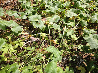 |
| I think this is some kind of wild squash, but I'm not sure. |
We hiked back through Greensprings, where the music festival had been, and I saw this sign. I think this was what everyone in Seiad Valley had been so opposed to:
 |
| I think this is the monument that everyone in Seiad Valley was so opposed to. |
 |
| Man in Black emerging from another cabin maintained for backcountry skiers, where we had spent the night along with Fireball. |
In the morning after sleeping in another cabin maintained for backcountry skiers, we ran into Bernie and Charlie, who we'd met a few days earlier. They'd given us some fresh melon and had been starting a 200-mile section of the PCT on horseback, and now we found them 90 miles in. A couple of their horses weren't doing well so they were having their wives meet them at the next road, and I told them that I was sorry they didn't get to do the whole trip, but more glad that they were responsive to the needs of their horses. I've seen some less responsible animal owners on this trip, and it was good to see people putting their animals' needs first.
 |
| The cabin had an old-fashioned pump system for water |
 |
| Sweet Tooth and Pants Off Dance Off in their rain ponchos that fit over their packs - I was pretty impressed with these. |
Some sections of the trail had these lava rocks, which were almost impossible to walk on. I couldn't figure out why they would move them in and cover the trail with them, until I got to an area where the rocks had been worn down already. Before we got to the section where they'd been worn down, presumably by foot traffic, we were laughing hysterically over the state of the trail.
"Seriously, did they try to find the absolute f***ing hardest thing to walk on, and truck it in from somewhere?"
"It was a close race between these rocks and used hypodermic needles, but at the last minute they decided to go with these rocks!"
 |
| The fresh rocks, which were really tough to walk on |
 |
| The worn down rocks, which were a perfect path |
 |
| Bernie and Charlie watering up their horses at the road before going up to the parking lot to meet their wives |
We got caught by a rainstorm, which included so much hail that afterward it lay on the ground like snow:
 |
| There was so much hail that it lay on the ground like snow. |
 |
| The 1800-mile mark is significant because it means that you've hiked more than 2/3 of the trail. |
 |
| Huckleberries, which are really tasty but REALLY tiny |
Crater Lake was the most "upscale" of any of the parks that the PCT had gone through. It's such an attraction that it seems to be a huge money maker, and the park's rangers have a reputation for making sure that PCT hikers don't interfere with that on their way through.
All of the hikers that were around Crater Lake at the same time as us did the same thing, which was to camp a few miles before the lake, get up in the dark, and hike up to the lake for sunrise.
An informational poster said "Crater Lake is known for its unique clarity, purity, and brilliant blue color. Formed in a caldera, the basin of an erupted volcano, it is the deepest freshwater lake in the United States. No streams empty into the lake bringing sediment that would cloud the waters. The lake is filled by rain and snowmelt. Its depth and extreme clarity make the brilliant color possible.
A lodge on the lake had decently priced breakfasts and the weather was bad, so all of the hikers went there. The friendly bartender named David gave me free "birthday" Bloody Mary, complete with a song and a candle burning in one of the olives.
 |
| David! |
 |
| The cutest dog ever drinks from a water fountain |
The restaurant was in the ground floor of a hotel and the lobby had a fireplace, so we napped and rested through some intense rainstorms before heading out. We bought cheap rain ponchos at the store, which were big enough to cover our backpacks. Ironically, this was supposed to be the beginning of a 27-mile dry stretch, and it technically was. The rain soaked into the ground and there wasn't any way to take advantage of it, but I refused to carry five liters of water in the cold rain, and went with three. It turned out that there was a small cache after 17 miles that I took a liter from, and four was enough in that weather.
 |
| Part of the trail once we started to leave the rim of the lake - you literally couldn't see 50 feet in front of you. |
I am curious about what's afflicting the trees like this one below. I've seen lots of it, but this area just north of Crater Lake was the worst, and it definitely kills them, because the dead trees had more deformities than the living ones.
 |
| I don't know what kind of disease or parasite this is, but the trees in this area had been hit pretty hard by it and many of them were dead. |
 |
| The Oregon/Washington high point seems a little insignificant after the high Sierras, but here it was. |


No comments:
Post a Comment