Piper's Mom gave me a ride into Chester, where I took care of the rest of my business and slept of the floor of a hotel room rented by Solstice, Explagrance, and Golden Boy.
 |
| Open at 7 AM, which is apparently not early enough to learn how to spell "laundromat." |
Mid-day the next day I hitched back to the trail with Krusteaz, a young hiker who had recently finished college in Boulder. A man named Bruno was waiting for his daughter, a thru-hiker named Rainmaker, and treated us to Sierra Nevadas which gave us an excuse to sit around for another hour before finally hitting the trail. Krusteaz and I would hike together for the next two days and then intermittently again after that. He was positive and energetic and would get excited and wax poetic on a wide range of subjects, but none quite as intensely as
water polo.
 |
| One of the stranger things I've seen on the trail was the seat from a car - I think I'm pretending to drive here... |
 |
| These little signs were at a spring, and I have no idea what they were supposed to mean. |
 |
| In this section of the trail the dead wood had been stacked into piles. |
The next morning I took a short side trail down to
Terminal Geyser. Terminal Geyser spews steam instead of liquid water, and it was honestly maybe my favorite thing I've seen so far on the trail. I don't know why, but I actually got kind of emotional being up close to it, in a way that I never did on Whitney or on any of the passes in the High Sierras.
 |
| Terminal Geyser |
 |
| Terminal Geyser |
 |
| Terminal Geyser |
 |
| Boiling water coming out of the geyser |
 |
| The ground around the geyser |
 |
| This stream coming from the geyser was hot enough to burn my hand 50 yards down from its source. |
 |
| My self-portraits at major landmarks are getting funnier and funnier... |
Back on the trail I had my second bear encounter of trip. This time the mother bear and I noticed each other at the same time so I didn't have time to decide what to do, but luckily she lumbered off and her two cubs followed her. I thought of the irony of having carried a three-pound bear canister through the 300 miles where they were legally required, only to begin seeing bears after finishing it. Sonora Pass is the last place they're required and when I came out from there to meet my family I got rid of it, not believing I'd ever come anywhere near a bear on the trail. I hadn't even seen a footprint or scat, or any evidence that I actually needed to manage my food for bears. If I had, I probably would have bought an
Ursack, which is what many hikers switch to after Sonora Pass. An Ursack is a cloth bag with kevlar sewn into the fabric. They're not legal substitutes for canisters where canisters are required because a bear will destroy the food inside the sack while trying to get into it, but the bear won't be able to get into the sack and become habituated to human food, so the Ursack still protects bears.
 |
| Momma bear is visible to the left of the trees, but I think both baby bears are running behind the trees here. |
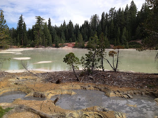
Next I came to
Boiling Springs Lake, which was almost as exciting for me as Terminal Geyser, and even more scenic. The link above explains that there are steam vents underneath the lake, and that it's temperature is around 125 degrees.
 |
| The shore of Boiling Springs Lake |
|
 |
| Mud boiling around the lake |
 |
| Boiling Springs Lake |
 |
| Boiling Springs Lake |
A former thru-hiker who I'm talked to for a few minutes in Truckee had said that in terms of cool things to see it was basically all downhill after the High Sierras, but I strongly disagree. Terminal Geyser and Boiling Springs Lake are part of
Lassen Volcanic National Park, and I personally was more excited by them than by anything else I've seen.
Krusteaz caught up with me right before Drakesbad Guest Ranch and we wasted a few hours sitting on the front porch of their main building, drinking beer and cooking meals in our JetBoils. We hiked out in the afternoon and spent the rest of the day walking through a former burn zone, where the trees were blackened and dead but still had their needles. The needles were a bright orange color, and I simply can't understand how they could have managed not to burn in a fire intense enough to blacken the entire trunks of the trees.
 |
| How can the trunks of these trees be blackened but the needles not be - shouldn't they be more flammable? |
 |
| Krusteaz! |
 |
| I don't really know what the best adjective for this landscape is - surreal? Orwellian? |
I kept hearing a strange noise coming from the trees. Maybe it was made by some kind of insect? I don't know if I captured it in this clip or not (I haven't figured out how to play it on the computer I'm posting from), but I'm just dying to know what it is...
We camped together again that night in a small meadow, where deer grazed around us, seemingly unbothered by our presence. We discussed the possibility of being trampled by deer in our sleep, and fell into fits of giggles. We started a song, although we only got through one verse:
Don't step on my head
with your little deer feet
I really don't want
my face turned into meat
Hiking down into Old Station the next day we met a former thru-hiker named Strawberry, who gave us cokes. He was hiking up to a stream to put them in for incoming hikers, but had met so many hikers on his way there that he was down to only four cokes. The timing of our meeting was perfect, and I chugged my coke before charging up the last uphill stretch before Old Station.
 |
| Strawberry! |
 |
| The trail into Old Station |
Old Station seemed to basically consist of just a convenience store, but we sat around outside it eating lunch made from food scavenged out of the hiker box with the four or so other hikers who were there. In case I haven't explained hiker boxes, they're boxes located anywhere along the trail that hikers congregate, where you can leave anything that you don't want to carry and can take anything that you need. Some have nothing but a few mostly-empty fuel canisters and bags of unidentifiable powdered mixes at the bottom, but a lot of good food had been left in this one, and we all ate our fill and took some more for the road.
 |
| Redneck love - we saw this on the way out of town. |
Shortly after leaving we passed another short detour, to
Subway Cave. Subway cave is a long tube that was created by lava flow, and while it wasn't quite as exciting as Lassen, it was pretty neat.
 |
| It's too dark to take pictures in Subway Cave, so they must have set up lighting to take this picture. |
 |
| Heading down into Subway Cave |
After leaving the cave I returned to the trail and caught up with Krusteaz at an observatory point on top of a hill. I had cell service there for the first time in quite awhile, and I looked at my e-mail account. I had an e-mail from PayPal saying that Fats had given me another donation after reading my blog post about being turned in to unemployment being determined to finish the trail. There was more to his message, but the basic message was "keep hiking," and the sentence that I remember was "don't let the bastards get you down!" I felt buoyed by this, and left the observation point in high spirits, determined to reach Canada.
 |
| A panorama from the observation point |
 |
| Apparently lightning starts more of these fires than people do. |
 |
| One of the more post-apocalyptic landscapes I've hiked through |
 |
| Cows use the PCT too! |
I used that energy to hike into the night. I walked along the ridge north of the observation point with the goal of reaching a well-known cache on it, but the trail was so rocky that I kept stumbling, and realized that the likely outcome of pressing on was hurting myself.
 |
| I've started seeing scorpions in the last few weeks, but they're very small, like this one. |
There were no camping spots on the ridge so I just found a six-foot
stretch of the trail without too many rocks and laid my bag out there, cowboy camping despite several recent scorpion sightings. I slept for a few hours and rose as it was getting light. I made some coffee and started walking along the ridge, starting out slowly. I saw a new mountain, on the east side of the ridge. I wondered what the mountain might be called, and noticed that it looked a little like Mount Lassen to the south. After a little while, I noticed something strange - the sun was rising in a different place than usual. In my delirium I wondered what kind of natural phenomenon this was. I kept wondering this, and kept walking, for at least another ten minutes before I realized that I was walking south. Yes, that's right, I walked south for 40 minutes before I realized that the sun NEVER rises in the west.
I turned around and tore northwards, reaching the spot where I'd camped in only 20 minutes. Shortly after that I reached the cache on the ridge, where I loaded up on water and ate in the shade of the shelter before heading north again.
 |
| This water cache was in the middle of what would have been one of the longest dry stretches on the entire PCT - thanks, guys! |
 |
| It's hard to see in this picture, but here is my first view of Mount Shasta. |
 |
| I love these plants, but I have no idea what they are. |
 |
| Really California, I've had enough desert. |
I passed the
Crystal Lake Trout Hatchery, and then crossed the road where hikers hitched into Burney. Krusteaz and I had both planned to go into town there but I wasn't that low on food and realized that I could make it as far as the Burney Falls State Park in time to get a beer from the store, so I continued on.
 |
| The Crystal Lake Trout Hatchery |
Just past the road I stopped to have a phone call with my sister. It meant that I might not be able to make the store in time but the call was more important than having a beer, and I sat by the edge of the road for nearly an hour. When we finished talking I realized that I could still make it if I hiked incredibly fast, and took off along the trail. A mile later I came to the Wild Bird Cache, which was one of the more amazing things I've seen on trail. It had water, sodas, candy, other snacks, and top ramen. It had a register to sign, and a radio to listen to while you sat in the chairs provided. I kicked myself for sitting a mile away for an hour, when I could have been sitting there, but grabbed some soda and wrote a thank you in the register before tearing off again.
 |
| The most amazing surprise stop for hikers |
 |
| Seriously, who designed this sign? Did no one look it the design over before they went ahead with it? |
I made it into Burney Falls with a half-hour to spare, which meant that I'd done 30 miles that day (including the mile south and the mile back north to where I started), and had hiked four miles per hour for two of the last hours of the day.
Burney Falls was an interesting stop - the falls were beautiful and there were a lot of nice people around, but it was the most hiker-unfriendly place I've been on the entire trail. Going into the store the woman behind the counter actually chewed me out for ordering a hot dog and ice cream before I was ready to pay for my groceries (I'd assumed this was the logical order, because they would need a few minutes to prepare them and would grab the thing or two I needed off of the shelves while they were doing it). She had no teeth so I couldn't understand every word, but I understood that she despised me and my kind. Even at Echo Lake they'd managed to be polite to hikers while they were taking their money. Outside the store the manager was rude, but the girls inside smiled and gave very decent service while I was inside buying things from them. At Burney Falls they also threw the hiker boxes away while I was there, and one hiker who really needed some heet (stove fuel) that had been in them wasn't allowed access to the trash. It didn't make sense because it sent him into town, so instead of resupplying at the store as he'd planned he spent no money there, and I really didn't get the logic on the part of the Burney Falls General Store.

I camped back on the trail with a hiker named El Hefe but was wiped out from the day's exertion, and spent most of the next day lounging around the park. While I was there I met Paul and Carol, which was really cool. Paul had thru-hiked in 1980, which was amazing because I don't even think the trail was completely finished then, and there definitely weren't a bunch of trail angels or water caches or anything like that.
"When you were going by that aqueduct," he asked, "did you unscrew those things and lower something down get water out?" I stared at him blankly. Another hiker explained that those weren't open anymore, but that there were water caches in the area.
Something else that made Paul's adventure amazing was the fact that 1980 was the year that Mount Saint Helens erupted, so he'd spent a good chunk of the trail walking through ash.
Paul and Carol!
Carol took me to the their RV and they gave me oranges from their back yard, and I was thrilled to have met them.
 |
| Burney Falls |
I'm trying to wrap this post up, but I've been meaning to learn more about the
Civilian Conservation Corps. I saw a similar informational placard last month in the San Juan Islands in Washington when I was up meeting my brother Kevin, and am just generally interested in that piece of American history.
I spent the day seeing the falls, checking out other things in the park, and talking to people, and then finally hit the trail again in the evening. While I was there I was able to briefly access my e-mail account, and I found out that Roy, a friend from Tbilisi, had donated money on the blog to help me finish the trail in response to recent events. Later the same day I found out that Harry, another good friend from Tbilisi, had also donated money in response, telling me not to quit. I was amazed by the generosity of friends new and old, and set off in the afternoon newly determined to hike as far as I could.


No comments:
Post a Comment